


By Christian Stafford & Sam Haas, news staff
Curious explorers will soon be able to virtually navigate the Charles River from the comfort of their homes, thanks to the efforts of a Northeastern University alumnus.
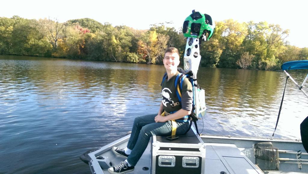
Evan Bradley, a 2015 graduate and special projects associate at the Charles River Conservancy (CRC) – a group dedicated to preserving and maintaining the river and its parklands – is leading the project to map Boston’s river. The CRC teamed up with Google to take extensive photos of the river and its surroundings using Google’s “Trekker” street-view camera. In the past, the camera has been used to create street-level visuals of landmarks worldwide.
The CRC did not initially intend to film the Charles River with Google’s camera, according to Bradley, who began working with the group as a co-op.
“Google doesn’t sponsor printed materials, but did offer an event and discussion with the featured authors in ‘River Stories III,’” Bradley said. “River Stories III,” a publication honoring CRC’s 15th anniversary, was the focus of Bradley’s senior capstone project, which quickly evolved after Google came aboard. “Along with this event, they offered us the opportunity to film the Charles with the Trekker camera. We agreed, and things progressed from there.”
Alongside the CRC, the Massachusetts Department of Conservation and Recreation (DCR) and the Charles River Clean Up Boat helped coordinate mapping. According to Bradley, the early stages of filming the Charles River proved to be somewhat challenging.
“Coordinating with the DCR and the boat proved to be the most difficult as we arranged dates to film on,” Bradley said. “We had to navigate conflicting schedules, weather and riverside preparation for the Head of the Charles [Regatta].”
The project may connect individuals to nature via their computers or mobile devices, according Brian Helmuth, Northeastern University professor of ecological policy and sustainability.
“The use of virtual tours that allow users to explore the world from their desktop or mobile device is really taking off,” Helmuth said. “In a digital age, it will hopefully serve as a ‘hook’ to reconnect people with the natural environment.”
Younger generations of individuals seem to enjoy virtual tours of areas such as underwater and coastal sites, Helmuth continued. However, he expressed concern that technology, such as the kind being used to map out the Charles River, could further isolate individuals from the outside world, instead of drawing them closer to it.
“What we don’t yet know – but hope to find out – is if technology like this really lures users into wanting to know more about the natural world in which they live, or whether it serves to distance them even further,” Helmuth said. “We are just starting a National Oceanographic and Atmospheric Association-funded project with the Museum of Science and Arizona State University to try to answer some of these questions.”
Officials at the DCR declined to comment about the project or its potential impact on people’s interest in the river, other than to clarify the department’s involvement.
“We issued Google and the CRC a film permit for special filming. They’re the driving force behind this,” Kevin O’Shea, a DCR spokesman, said.
CRC staff, aside from Bradley, also declined to comment.
One of the goals of the CRC is to make the Charles River and its surrounding parks more accessible, which Bradley said is furthered by the virtual maps. He noted that the project opens the area to a worldwide audience.
“When these images go live, one will no longer need to be near the Charles River or its parklands to experience them,” Bradley said. “Whether you’re a local resident looking to find a new picnic spot along the Charles, a tourist looking for the best place to capture the Boston skyline or someone looking to experience the gorgeous foliage of a New England autumn for the first time, this project will help you.”
The Charles River should be celebrated, said Valorianne Steier, a sophomore linguistics major at Northeastern University, who added that more people should be made aware of what Boston’s famous river has to offer.
“Given that the river runs right through the city, I think it’s certainly appropriate that there be a visual map,” Steier said. “Boston has a lot of activities available to do or watch on the river that not many people are aware of. Hopefully this can raise awareness on what Boston has to offer on the river.”
The completed project will go live in early December, alongside the Google-sponsored event celebrating “River Stories III” and its authors on Dec. 10.
Photo courtesy Evan Bradley